Multi‑modal detection
Radar, RF, passive emissions, and AIS fused into one picture. Defeating one layer still leaves three.
01 / 09VEILWATCH COASTAL · v1.0 · MARITIME DOMAIN AWARENESS
A passive, multi‑layer surveillance node for small island and coastal states. Sovereign‑owned. Solar‑capable. Deployed along the coastline you actually need to watch — at a fraction of the cost of legacy radar.
THE PROBLEM · TWO CLASSES OF VESSEL
Every coastline carries two populations of vessels. Cooperative traffic announces itself. Non‑cooperative traffic — the kind moving narcotics, fishing illegally, or staging a landing — deliberately doesn't. Legacy systems were built for the first group.
COOPERATIVE
Commercial shipping, registered fishing fleets, and most recreational craft transmit position and identity over standard transponders. They show up on every coast guard screen in the region. They are not the problem.
NON‑COOPERATIVE / DARK
Vessels with transponders disabled, spoofed, or never installed have moved freely through coastal waters for decades. They are the vessels that matter most — and the ones legacy radar networks were too expensive to catch. VEILWATCH Coastal closes that gap.
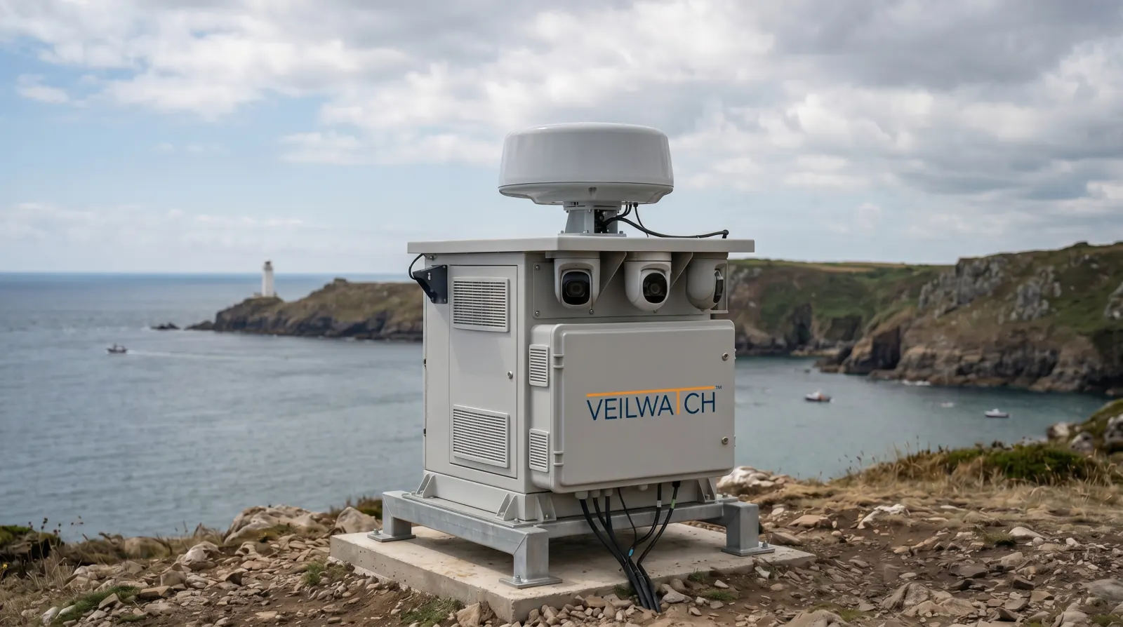
THE NODE · DISTRIBUTED ARCHITECTURE
A single VEILWATCH Coastal node fuses marine radar, RF intelligence, passive emissions analysis, and AIS into one operational picture. Each node covers a defined coastal segment; nodes network together for continuous coverage along an entire coastline.
CORE CAPABILITIES · 09 PRIMITIVES
Every detection layer is independent. Every layer is recorded. A vessel attempting to defeat one method is still seen by the others — and the gap itself becomes evidence.
Radar, RF, passive emissions, and AIS fused into one picture. Defeating one layer still leaves three.
01 / 09Vessels that appear in radar or RF without an expected identity signal are flagged automatically as investigation cases.
02 / 09Cooperative data is cross‑checked against physical contacts. Mismatches, gaps, drop‑offs, and spoofing surface in real time.
03 / 09Loitering, sudden course changes, rendezvous events, and approaches to sensitive shoreline assets are flagged the moment they happen.
04 / 09One map. One feed. One source of truth — accessible from a central command facility or any authorised device in the field.
05 / 09Each node covers a coastal segment with overlap. Nodes network together to deliver continuous coverage along an entire coastline.
06 / 09Designed to operate on minimal power. Viable for remote shoreline sites without grid infrastructure.
07 / 09Cellular, satellite, or microwave uplink. If connectivity drops, the node continues operating and recording locally.
08 / 09No third‑party sensor network, no foreign data licensing, no outside subscription. The host government owns sensors, data, and analytics.
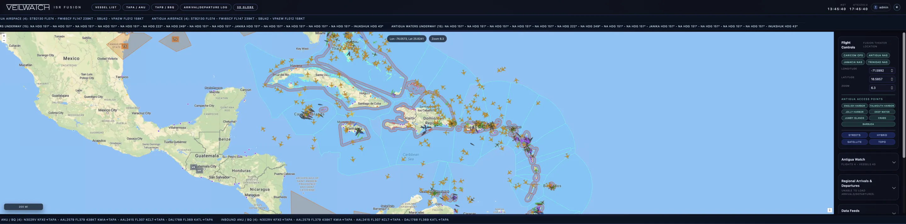
09 / 09CASE · DARK CONTACT INVESTIGATION
A representative single‑node coverage area. Cooperative vessels in cyan. Cleared and resolved contacts in green. A dark contact, present on radar and RF but not transmitting AIS, in red — flagged the moment it loitered off the reef passage.
Every contact is captured, classified, geolocated, and fed into one map. Authorised officers see the same picture from the command facility or the field.
USE CASES · COASTAL SECURITY & REGULATORY
Detect inbound runs, rendezvous events, and shoreline drop‑offs across reef passages and harbour approaches.
Identify foreign vessels operating inside the EEZ without licence or transponder.
Monitor approaches across the entire territorial sea line, not just the patrol track.
Last known position and track history available to responders within seconds of an alert.
Reef passages, anchorages, and harbour mouths under continuous watch — including overnight.
Compliance evidence with timestamped tracks, boundary breaches, and gear‑use behavioural signatures.
Marine protected area incursions, illegal dumping events, and coral‑reef anchoring detected and recorded.
Resorts, energy facilities, cruise terminals, and undersea cable approaches protected from unauthorised closures.
DESIGNED FOR SOVEREIGN OPERATION
National infrastructure, deployed and operated by the host government. Data captured by the system stays within the host jurisdiction and is governed by the host's laws.
Fundamentally different from commercial maritime intelligence services that resell aggregated global data back to governments on a subscription basis.
NODE · SPECIFICATIONS
DETECTION RANGE
24 nm
Marine radar return on a typical 12m hull, sea state 3.
DETECTION LAYERS
04
Radar · RF intelligence · passive emissions · AIS.
POWER
~120 W
Solar‑capable in standard configuration. Grid optional.
UPLINK
Cell · Sat · μW
Auto‑failover. Local recording continues if all uplinks are lost.
DEPLOYMENT
≤ 1 day
Per node, on prepared ground. Networked into existing nodes on connection.
BUILT FOR
Coastlines
Reef passages, harbour approaches, EEZ boundaries, remote shoreline.
OWNERSHIP
Sovereign
Hardware, data, analytics, and operating picture all retained by host nation.
OPERATING TEMP
−10 / +55 °C
Salt‑fog rated. IP66. Cyclone‑season tested.
DEPLOYMENT · CARIBBEAN AND BEYOND
Pilot one node on the segment that troubles you most. Scale to a full coastline as the picture justifies it.